Βορειον Ακρον
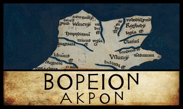
The most north-westerly point on Claudius Ptolemy’s map of Ireland is a headland to which he gives the simple Greek name Βορειον Ακρον, or Northern Promontory. This has the distinction of being the very first item in Ptolemy’s Geography, which records the latitudes and longitudes of almost 8000 cities, villages, peoples, mountains, rivers and other landmarks between this Irish headland and Sousouara Island off the coast of Sri Lanka.
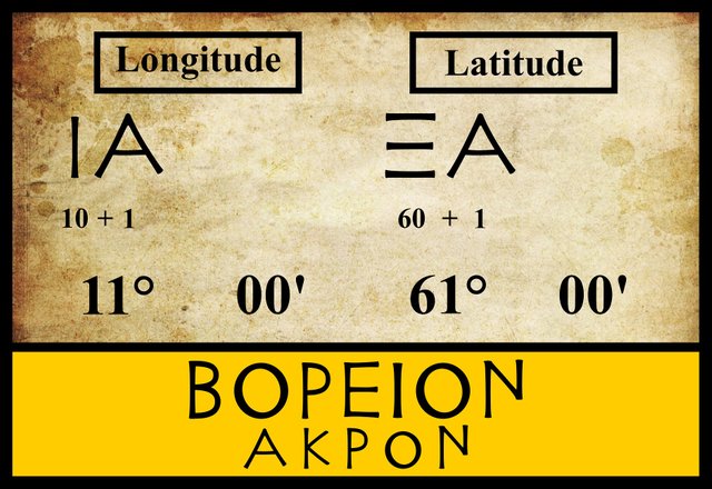
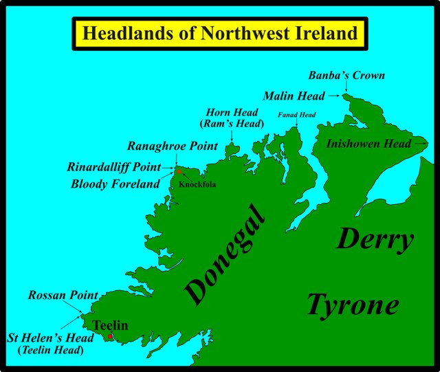
There are several headlands on this part of the Irish coast, any one of which may have been meant by Ptolemy, but over the past four centuries interest has focused on just three: Bloody Foreland, Malin Head and Rossan Point. The identity of this landmark is further confused by discrepancies in its location in the manuscript sources. Most modern editions place it in longitude 11° E and latitude 61° N, but some manuscripts place it as many as two degrees to the east of this, while some place it 20 minutes further to the north:
| Edition or Source | Longitude | Latitude |
|---|---|---|
| Müller | 11° 00' | 61° 00' |
| Wilberg | 11° 00' | 61° 00' |
| Nobbe | 11° 00' | 61° 00' |
| Σ, Φ, Ψ, M | 13° 00' | 61° 00' |
| A | 12° 00' | 61° 20' |
Σ, Φ and Ψ are three manuscripts from the Laurentian Library in Florence: Florentinus Laurentianus 28, 9 : Florentinus Laurentianus 28, 38 : Florentinus Laurentianus 28, 42.
M is the Editio Argentinensis, which we have met several times before. Based primarily on Jacopo d’Angelo’s Latin translation of Ptolemy (1406), it also drew on the writings of Pico della Mirandola. Many other hands worked on it—Martin Waldseemüller, Matthias Ringmann, Jacob Eszler and Georg Übel—before it was finally published by Johann Schott in Straßburg in 1513.
A is one of the Codices Parisini Graeci in the Bibliothèque nationale de France in Paris (Grec 1401).
13° E 61° N are also the coordinates Ptolemy records for the mouth of the River Vidva, which is the third item in his list of Irish landmarks, so these variants are probably transmissional errors. Karl Müller, who believed that they were editorial attempts to correct supposed errors in Ptolemy’s text, made the following telling comment:
In the table of Codex A, this promontory is placed at 12°, 61° 20'. The Rhobogdian Promontory is also placed in this same latitude so that nothing may be further north than that place which is called “Northern”. In fact, by this fabrication the creator of this table seems in his own mind to have corrected Ptolemy, not understanding that the “Northern” Promontory was only so called because it marked the northern extremity of the western coast of the island. (Müller 75)
Müller makes an interesting point here. He asserts that Ptolemy’s Northern Promontory is only northern in relation to the west coast, not in relation to the north coast. Any claim that the Northern Promontory must be the most northerly point of the island—ie Banba’s Crown or Malin Head—is misguided. That is not why Ptolemy called it Northern.
No variant readings of Ptolemy’s Βορειον Ακρον are recorded by any of the modern editions.
Identity
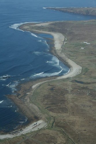
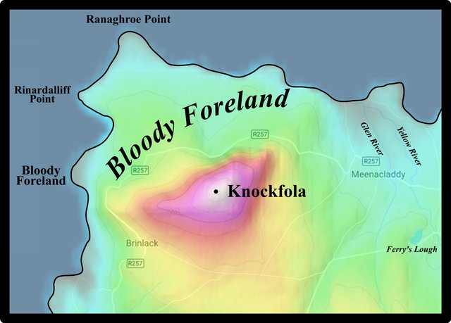
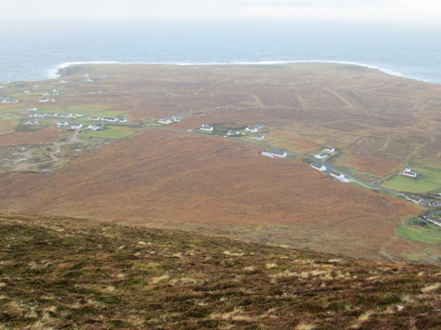
In 1607, the British antiquary William Camden identified Ptolemy’s Northern Promontory with St Helen’s Head, which is thought to refer to the north-western headland now known as Bloody Foreland (Darcy & Flynn 58). Curiously, the exact location of Bloody Foreland is uncertain to this day. On some maps it is identified with the most north-westerly headland, while on other maps that particular headland is called Ranaghroe Point, with Bloody Foreland lying further along the coast, about 2.4 km to the south-west. Between the two is another headland: Rinardalliff Point. All three are interchangeably referred to as Bloody Foreland.
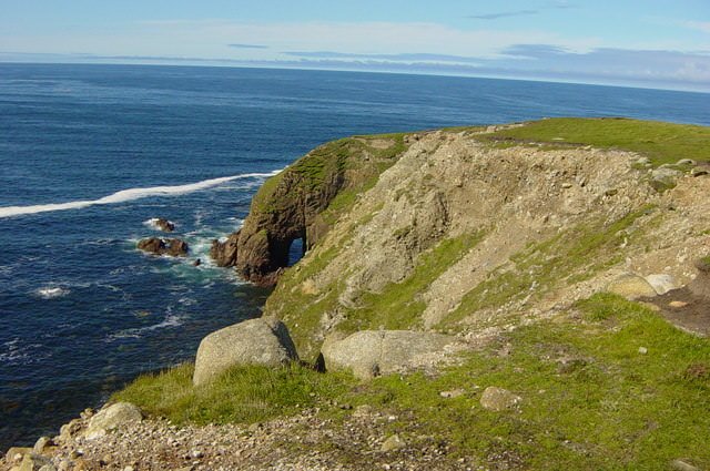
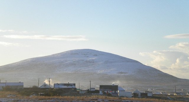
The curious name of this landmark is derived from the Irish Cnoc Fola, which literally means Hill of Blood. This is possibly a reference to the mythological figure Balor of the Evil Eye, who either died here or wounded one of his enemies here. Cnoc Fola, or, as it is known in English, Knockfola, is a prominent hill, and not a coastal headland. It lies about 2 km from the sea, but being 368 m high, it is easily visible from offshore. Presumably, the name Bloody Foreland originally referred to all the land lying between Knockfola and the sea. In tracing the etymology of this word, the Oxford English Dictionary cites the Icelandic forlendi, which means “land between hills and the sea”.
William Faden’s map of 1798 calls Ranaghroe Point Bloody Farland Pt. This variant of Foreland crops up on many early maps. According to the Oxford English Disctionary, farland is an obsolete form of foreland.
St Helen’s Head
But is Camden’s St Helen’s Head the same as Bloody Foreland? Some old maps have a Tiellen Head—or Telling Head, or some other variant—which is said to be a corruption of St Helen’s Head. But Tiellen Head is usually placed at, or close to, Rossan Point, one of the most westerly points in County Donegal. William Faden’s map is one such example.
The Irish antiquary James Ware, who flourished in the middle of the 17th century, is my source for the claim that Tiellen Head is a corruption of St Helen’s Head, while Walter Harris, another Irish antiquary who edited Ware’s works in the 18th century, makes clear the confusion surrounding the identity of this landmark:
Telen-Head, corrupted from St. Helen’s Head. See what is said of this before p. 38. under Boreum Promontorium.
Turning to page 38, we read the following (Walter Harris’s editorial comment is in square brackets):
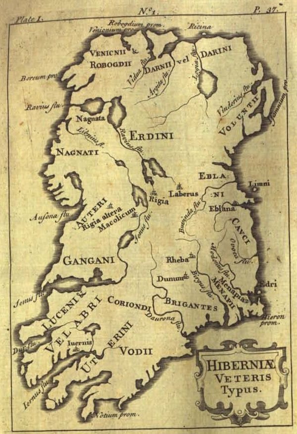
Boreum, a Promontory: At present it is called Saint Helens Head, or Telen, in the County of Donegall; [and signifies no more than the North Cape. I must observe that our Author [ie James Ware] has in his Map misplaced this Promontory, and given it a different Position from what Ptolemey has done, by fixing it South West of the Venicnii, whereas Ptolemey places it North of them. (Ware & Harris 38)
In other words, James Ware identfied St Helen’s Head with Rossan Point (or one of the nearby headlands), while Walter Harris identified it with Bloody Foreland.
John Speed’s map of 1611-12 has a town called St Helena on the western coast of Donegal, with St Hellens Haven offshore, but these lie in the vicinity of Portnoo, about 25 km north-east of Rossan Point. Speed’s St Hellens Haven is now called Gweebarra Bay.
Searching online for further information about this shadowy place, which I had never heard of before, I found the following in the Encyclopaedia Perthensis:
(1.) TIELLEN, a sea-port town and harbour of Ireland, on the N. side of Donegal Bay, 7 miles ESE. of Tiellen head.
(2.) TIELLEN HEAD, a cape of Ireland, on the N. side of the entrance into Donegal Bay, and on the SW. extremity of that county, 25 miles W. of Donegal. Lon. 8. 25. W. Lat. 54. 40. N.
From these not completely consistent directions, it appears that the reference is to the modern town of Teelin. According to one of the scanned records at Logainm, an online database of Irish toponyms, this is indeed the original St Helen’s:
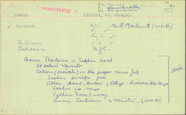
Teelin is on Donegal Bay, in the south of the county. So, clearly the early cartographers have seriously misplaced it. How it acquired the name St Helen’s I do not know. The Irish name, Teileann, does not mean anything. Some online sources claim it means dish, but I have not found any Irish dictionary that supports this. The closest I have come is the old word teillén, which denotes some kind of metal vessel. So it seems that St Helen’s was the original name.
St Helen’s Head would then be the most westerly point in the county. And, indeed, this headland is sometimes called Teelin Head today. When and by whom Teelin was founded are still mysteries to me.
Later Opinions
Karl Müller not only identified Ptolemy’s Northern Promontory with Bloody Foreland but also provided helpful coordinates:
The Northern Promontory seems to comprise today’s Bloody Foreland (55° 8' lat.) (Müller 75)
55° 8' is the latitude of both Knockfola and the southernmost of the three headlands closest to it. Ranaghroe Point is at 55° 9.5' N, while Rinardalliff Point’s latitude is 55° 9' N. Perhaps Müller identified Ptolemy’s Northern promontory with Knockfola, and not one of the coastal headlands. As I said, Knockfola is a prominent landmark and easily visible from a ship offshore.
Goddard Orpen, writing shortly after the publication of Müller’s edition of Ptolemy’s Geography, also opted for Bloody Foreland, but he did not spell out which particular feature he meant this.
Around the same time, Charles Trice Martin opted for Malin Head. Today, the etymologists at Romaneranames concur. Have they too been led astray by the name, which, as they point out, was ancient Greek for ‘northern point’?
Louis Francis, as usual, has gone his own way:
Paragraphs §1/2,4,6 and 8 describe the physical characteristics of the coasts of Hibernia, thus §1/2 describe the north coast from west to east and the locations described consist of three promontories and two river outflows. The two eastern of the three promontories can be reasonably identified with Rathlin rather than Fair Head and Malin Head on the north coast proper but the third promontory, lying 1° 50' to the west and 0° 20' to the south of Malin Head would bring us into the vicinity of Rossan Point on what is really the north-western coast of Donegal. (Francis)
For once, Francis is not alone: Robert Darcy and William Flynn agree with his choice. And, as we have seen, James Ware probably meant Teelin Head, which lies less that half a kilometre southwest of Rossan Point, when he identified Ptolemy’s Northern Promontory with St Helen’s Head.
| Bloody Foreland | Malin Head | Rossan Point | ||
|---|---|---|---|---|
| Camden (1607) | - | - | ||
| - | - | Ware (1654) | ||
| Harris (1745) | - | - | ||
| Müller (1883) | - | - | ||
| - | Martin (1892) | - | ||
| Orpen (1894) | - | - | ||
| - | Mac an Bhaird (1991-93) | - | ||
| - | - | Francis (1994) | ||
| - | - | Darcy & Flynn (2008) | - | - |
Source: Darcy & Flynn 56
My personal choice is Knockfola, the hill rather than any of the coastal headlands. At 368 m tall, it is the most prominent feature in the landscape as one doubles the cape. The headlands along this stretch of coastline are all less than 20 m in height.
References
- Alexander Aitchison (editor), Encyclopaedia Perthensis, Volume 22, John Brown, Edinburgh (1816)
- William Camden, Britannia: Or A Chorographical Description of Great Britain and Ireland, Together with the Adjacent Islands, Second Edition, Volume 2, Edmund Gibson, London (1722)
- Robert Darcy & William Flynn, Ptolemy’s Map of Ireland: A Modern Decoding, Irish Geography, Volume 41, Number 1, pp 49-69, Geographical Society of Ireland, Taylor and Francis, Routledge, Abingdon (2008)
- Charles Trice Martin, The Record Interpreter: A Collection of Abbreviations, Latin Words and Names Used in English Historical Manuscripts and Records, Reeves and Turner, London (1892)
- Karl Wilhelm Ludwig Müller (editor & translator), Klaudiou Ptolemaiou Geographike Hyphegesis (Claudii Ptolemæi Geographia), Volume 1, Alfredo Firmin Didot, Paris (1883)
- Karl Friedrich August Nobbe, Claudii Ptolemaei Geographia, Volume 2, Karl Tauchnitz, Leipzig (1845)
- Goddard H Orpen, Ptolemy’s Map of Ireland, The Journal of the Royal Society of Antiquaries of Ireland, Volume 4 (Fifth Series), Volume 24 (Consecutive Series), pp 115-128, Dublin (1894)
- Claudius Ptolemaeus, Geography, Biblioteca Apostolica Vaticana, Vat Gr 191, fol 127-172 (Ireland: 138v–139r)
- James Ware, Walter Harris (editor), The Whole Works of Sir James Ware, Volume 2, Walter Harris, Dublin (1745)
- Friedrich Wilhelm Wilberg, Claudii Ptolemaei Geographiae, Libri Octo: Graece et Latine ad Codicum Manu Scriptorum Fidem Edidit Frid. Guil. Wilberg, Essendiae Sumptibus et Typis G.D. Baedeker, Essen (1838)
Image Credits
- Ptolemy’s Map of Ireland: Wikimedia Commons, Nicholaus Germanus (cartographer), Public Domain
- Greek Letters: Wikimedia Commons, Future Perfect at Sunrise (artist), Public Domain
- James Ware’s Map of Ireland: The Whole Works of Sir James Ware, Volume 2, Plate 1, Number 1 (Oppositne Page 37), Public Domain
- Rinardalliff Point (top) and Bloody Foreland: © Daniel Collins, Fair Use
- Rinardalliff Point: © Mac McCarron, Creative Commons License
- Knockfola: Self-Made after Topographic Maps, Map Dato © 2018 Google, Fair Use
- Anonymous Handwritten Note on the Etymology of Teelin: © Government of Ireland, Fair Use
- Looking North from the Summit of Knockfola: © David-Guenet, Fair Use
- Knockfola, County Donegal: Unknown Copyright, Fair Use

really very talented history of ireland.. This type of content is very valuable here at Steemit and it is very valuable, you have been uploading very good quality content to Steemit for a long time and I love learning more because I can discuss new topics with my friends, I just have to give them the Thank you. my dear good friend.. @harlotscurse
Intarested post good article thanks for sheredear @harlotscurse
Wow! such a wonderful history and very nice article . Really I love your post. Thank you for sharing with us " Best of luck.
wesome post dear @harlotscurse and great writing thanks for shere.
Great history dear @harlotscurse
Wow..really this's amazing Rivers ..
And good article .i like your post ..
Thank you for share this amazing post.
dear @harlotscurse .
Excellent history .and Your writing is very good .i like your post.
.thanks for sharing with us.
Dear @harlotscurse
Excellent rivers photography and good article..dear @harlotscurse
Your writing is very good and your writing skills are like a professional writer. I love your writing.
Another fantastic and great story, excellent friend, very good job, great quality, your post, great friend